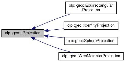
The identity projection used to work with geographic and world coordinates. More...
#include <IProjection.h>

Public Member Functions | |
| virtual GeoRectangle | GetGeoBounds () const =0 |
| Gets the geodetic bounds represented by the projection. | |
| virtual WorldAlignedBox | WorldExtent (double minimum_altitude, double maximum_altitude) const =0 |
| Creates the extent of world coordinates. | |
| virtual bool | Project (const GeoCoordinates3d &geo_point, WorldCoordinates &world_point) const =0 |
| Checks whether the geographic coordinates (latitude, longitude, altitude) of a point correspond to its world coordinates (x,y,z). | |
| virtual bool | Unproject (const WorldCoordinates &world_point, GeoCoordinates3d &geo_point) const =0 |
| Checks whether the world coordinates (x,y,z) of a point correspond to its geographic coordinates (latitude, longitude, altitude). | |
Detailed Description
The identity projection used to work with geographic and world coordinates.
Member Function Documentation
◆ GetGeoBounds()
|
pure virtual |
Gets the geodetic bounds represented by the projection.
- Returns
- The geodetic rectangle.
Implemented in olp::geo::EquirectangularProjection, olp::geo::IdentityProjection, olp::geo::SphereProjection, and olp::geo::WebMercatorProjection.
◆ Project()
|
pure virtual |
Checks whether the geographic coordinates (latitude, longitude, altitude) of a point correspond to its world coordinates (x,y,z).
- Parameters
-
geo_point The point position in geographic coordinates. world_point The point position in world coordinates.
- Returns
- True if the coordinates correspond; false otherwise.
Implemented in olp::geo::EquirectangularProjection, olp::geo::IdentityProjection, olp::geo::SphereProjection, and olp::geo::WebMercatorProjection.
◆ Unproject()
|
pure virtual |
Checks whether the world coordinates (x,y,z) of a point correspond to its geographic coordinates (latitude, longitude, altitude).
- Parameters
-
world_point The position in world coordinates. geo_point The position in geographic coordinates.
- Returns
- True if the coordinates correspond; false otherwise.
Implemented in olp::geo::EquirectangularProjection, olp::geo::IdentityProjection, olp::geo::SphereProjection, and olp::geo::WebMercatorProjection.
◆ WorldExtent()
|
pure virtual |
Creates the extent of world coordinates.
- Parameters
-
minimum_altitude The minimum altitude in meters. maximum_altitude The maximum altitude in meters.
- Returns
- The extent of world coordinates.
Implemented in olp::geo::EquirectangularProjection, olp::geo::IdentityProjection, olp::geo::SphereProjection, and olp::geo::WebMercatorProjection.
The documentation for this class was generated from the following file:
- olp-cpp-sdk-core/include/olp/core/geo/projection/IProjection.h